Mount Everest Base Camp Via Gokyo Lake Trek - 16 Days

Tour Info

trip code

EN-009

Starting Point/ End Point

Kathmandu

Accommodations

Lodge/ Tea House

Max Altitude

5545m (Kala Patthar)

Duration

16 days

country

Nepal

Trip grade

Moderate

Activities

Trekking

Best Season

February, March, April, May, June, September, October, November and December

Overview

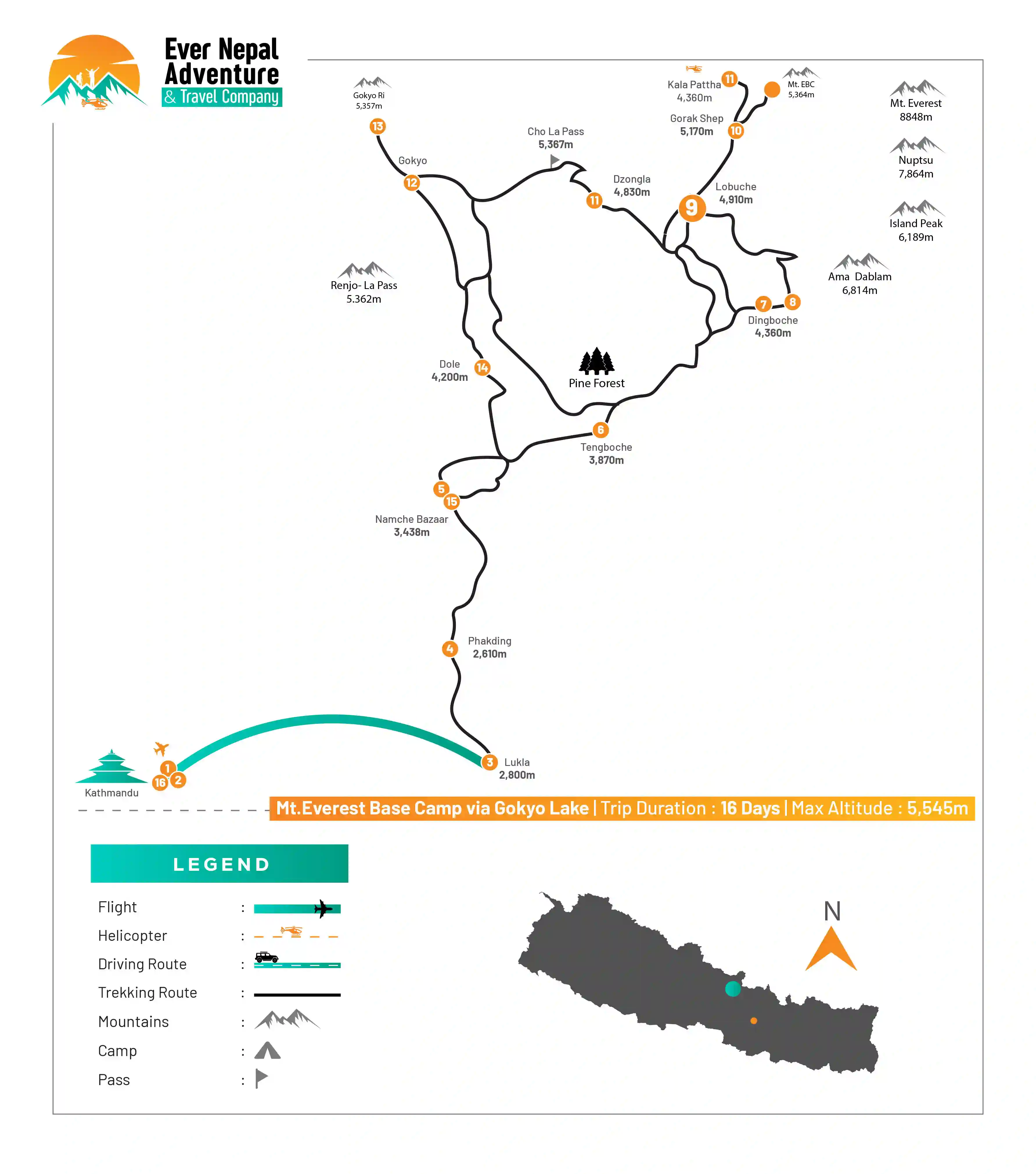
The Everest Base Camp with Gokyo Lake Trek connects two main parts of the Everest region; which are the Gokyo Valley and the Everest Base Camp area near the Khumbu Glacier. These two places are linked by the Cho La Pass, and passes through the lake side to the Everest side in a direct way. As the area is  at high altitude, the region is known for views of Everest, Lhotse, Makalu, and Cho Oyu. Both Everest Base Camp and Gokyo Lake lie inside Sagarmatha National Park, so the environment in both places follows the same high-mountain area. Everest Base Camp is located at the bottom of Mount Everest on the Khumbu Glacier. You can see the base of the Mt. Everest itself, the icefall, and nearby peaks like Lhotse, Nuptse, Pumori, and Lingtren. Because the ground is mostly covered with ice, rocks, and glacier surfaces, the whole area feels open and raw, giving it a true high-altitude atmosphere. The landscape slowly changes and leads you to Gokyo Lake towards the western side of the region, a group of calm, clear freshwater lakes resting at high elevation. Among them, the main lake, Gokyo Cho, stands out as one of the highest freshwater lakes in the world, making it a special and well-known point in the area.

Details

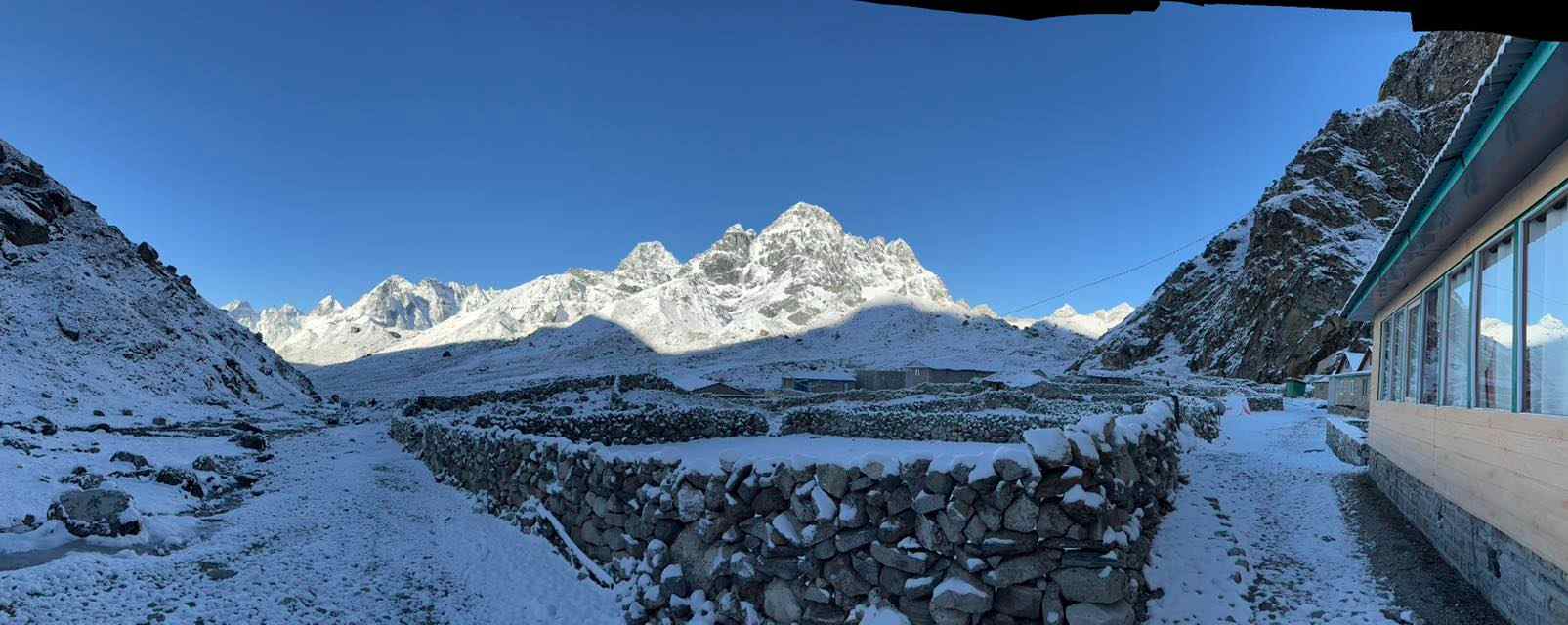
Everest Base Camp and Gokyo Lake are two well-known places in the same mountain region, and visiting them gives you a close view of tall mountains, wide glacier fields, and open land that stays cold most of the year.  You can see the tall mountains, the wide glacier fields, and the open land that stays cold most of the year. Also, you can visit nearby villages, including Namche, Khumjung, and Gokyo, which follow similar cultural patterns.  

Since these villages fall within Sagarmatha National Park, the wildlife is also shared, with animals such as Himalayan tahr, musk deer, and snow pigeons seen in different parts of the region, along with basic plants that grow in the cold. From the nearby hill, you can see several mountains lined together, which helps you understand the layout of the region. If you like observing daily life, you can enjoy watching how people grow small crops, take care of animals, or walk on narrow paths from one village to another.

Highlights

  • Explore the lower slopes and surroundings of the world’s highest mountain, Mount Everest.

  • Combine the Everest Base Camp trek with a visit to Gokyo Valley via the challenging Cho-la Pass (5420 m).

  • Trek along the Ngozumpa Glacier, the largest glacier in the Himalayas.

  • Enjoy the bright lakes in the Gokyo Valley.

  • Climb Kalapatthar (5550 m) and Gokyo Ri (5357 m) for clear views of Everest (8848.86 m), Lhotse, Nuptse, Cho Oyu, and other high peaks.

  • Visit the Sherpa town of Khumjung, where a ‘real’ yeti skull is kept.

  • See the natural beauty of the Khumbu glaciers and lakes.

  • Learn about Himalayan culture and traditions, visit Buddhist monasteries, and meet local Sherpa people.

Itinerary

Day 01: Arrival in Kathmandu and Pre-Trekking Preparation

You arrive in Kathmandu, and one of our team members meets you at the airport. After reaching your hotel, you can rest for a while. In the evening, you visit our office for a short briefing about the trip. During this meeting, you can meet your trekking guide and the concerned team members, ask any questions about the trek. You can explore the streets of thamel in the evening.

  • Max Elevation: 1,350 meters (Kathmandu)

  • Travel Distance:  6 to 8 kilometers

  • Travel Hours: 20 to 30 minutes

  • Accommodation: 3 Star Standard Hotel

  • Meal: Welcome Dinner

Day 02: A Full Day Guided Tour and Sightseeing in Kathmandu Valley

After breakfast at the hotel, your sightseeing tour starts around 8 AM. You can have a private vehicle for the whole day, making the trip comfortable and easy. A professional tour guide shall also be with you to explain the places you visit. The tour follows a simple schedule because it gives you enough time to explore each site without rushing, so you can move at a relaxed pace. You stop at several important heritage sites around the Kathmandu Valley. Each place has its own history and cultural value, which your guide helps you understand.

A. Pashupatinath (World Heritage Site):

Pashupatinath Temple is one of the most important Hindu temples dedicated to Lord Shiva. It stands on the banks of the Bagmati River. Non-Hindus cannot enter the main temple, but you can still see the temple complex and daily rituals clearly from the eastern side of the river. The temple has a two-tiered pagoda design and is well-known worldwide.

B. Boudhanath (World Heritage Site):

Boudhanath is one of the most sacred Buddhist sites in Kathmandu. Built in the 5th century, the large stupa has four pairs of Buddha’s eyes facing all directions, symbolizing awareness. You can see many Buddhist devotees walking around the stupa while rotating prayer wheels.

C. Patan Durbar Square (World Heritage Site):

Located in central Lalitpur, Patan Durbar Square showcases traditional Newari architecture at its finest. Many of its buildings were created during the Malla period, known for rich craftsmanship and art.

D. Swayambhu Stupa / Monkey Temple:

Located on a small hill, Swayambhu offers a wide view of the Kathmandu Valley. It is also called the Monkey Temple because many monkeys live around the stupa. This site is very important to both Buddhists and Hindus.

  • Max Elevation: 1,450 meters (Swayambhu Stupa, highest point in the Kathmandu sightseeing tour)

  • Travel Distance: 25 to 30 kilometers (total driving between sites)

  • Travel Hours: 6 to 7 hours

  • Accommodation: 3 Star Standard Hotel

  • Meal: Breakfast


Day 03: Fly to Lukla then Trek to Phakding (2610m/8562ft)

You wake up around 2 to 3 AM, drive for 4 to 5 hours, if you are flying to Lukla from Manthali, and take a short 20-minute flight. If the flight is from Kathmandu, you wake up around 5 AM, drive for about 20 minutes, and take a 30-minute flight. After landing in Lukla, the guide gives a short briefing and you have breakfast. The trek then starts with a simple downhill walk toward Phakding. You pass small villages, rhododendron areas, and can see animals like yaks, donkeys, and dzho. Phakding sits beside the Dudh Koshi River, so the trail moves gently down from Lukla.

  • Flight Duration: 20 minutes (Manthali to Lukla Flight)

  • Flight Duration: 30 minutes (Kathmandu to Lukla Flight)

  • Max Elevation: 2,840 meters (Lukla, highest point between Lukla and Phakding)

  • Travel Distance:  8 kilometers

  • Travel Hours:  3 to 4 hours

  • Accommodation: Tea house/Lodge

  • Meal: Breakfast, Lunch, Dinner and Teas/ Coffees

Day 04: Trek from Phakding to Namche Bazaar (3438m/11280ft)

The day starts with breakfast at the guesthouse, after which you continue along a route that passes through forest areas with small streams. The trek from Phakding to Namche Bazaar is about 11 km, and you usually need around 5 to 6 hours to complete it. As you follow the path, you cross the Dudh Koshi River on suspension bridges, where you can notice peaks like Thamserku in the distance. The route then enters Sagarmatha National Park, and you might be able to see Mount Everest from afar.

  • Max Elevation: 3,440 meters (Namche Bazaar, highest point between Phakding and Namche)

  • Travel Distance:  10 to 11 kilometers

  • Travel Hours:  5 to 6 hours

  • Accommodation: Tea house/Lodge

  • Meal: Breakfast, Lunch, Dinner and Teas/ Coffees 


Day 05: Acclimatization in Namche Bazaar (3,438m/11,280ft)

You can spend the day in Namche Bazaar for acclimatization, with the altitude reaching up to 3,870 meters (12,697 ft). Also, you can take a short trek of about 4.5 km, which usually takes 3 to 4 hours at a relaxed pace. During this time, you get to explore the town, visit small shops, or enjoy nearby viewpoints to get used to the higher altitude.

  • Max Elevation: 3,870 meters (highest point reached during acclimatization trek around Namche Bazaar)

  • Travel Distance:  4.5 kilometers

  • Travel Hours:  3 to 4 hours

  • Accommodation: Tea house/Lodge

  • Meal: Breakfast, Lunch, Dinner and Teas/ Coffees


Day 06: Trek from Namche Bazaar to Tengboche (3,870m)

You walk from Namche Bazaar to Tengboche, covering about 10 km in roughly 5 to 6 hours. The trail first goes uphill to Kyangjuma at 3,550 meters and then gently descends to Phungi Thanga at 3,250 meters. After crossing a suspension bridge, the path ascends to Tengboche village, where the largest monastery in the Khumbu region is located. From here, you can enjoy clear views of Mount Everest and Mount Ama Dablam.

  • Max Elevation: 3,870 meters (highest point between Namche Bazaar and Tengboche)

  • Travel Distance:  9 to 10 kilometers

  • Travel Hours:  5 to 6 hours

  • Accommodation: Tea house/Lodge

  • Meal: Breakfast, Lunch, Dinner and Teas/ Coffees


Day 07: Trek from Tengboche to Dingboche (4,360m)

To reach Dingboche from Tengboche, you have to cover about 9 km in 5 to 6 hours. The route descends through forested areas to Deboche at 3,320 meters and continues down to Imja Khola. After crossing a suspension bridge, you reach Pangboche village, where one of the oldest monasteries in the Khumbu region can be seen. Route then moves through small village areas such as Shomare (4,010 m) and Orsho (4,190 m) before arriving at Dingboche for the night stay at a tea house or lodge.

  • Max Elevation: 4,190 meters (Orsho, highest point between Tengboche and Dingboche)

  • Travel Distance:  5 to 6 kilometers

  • Travel Hours: 8 to 9 hours

  • Accommodation: Tea house/Lodge

  • Meal: Breakfast, Lunch, Dinner and Teas/ Coffees


Day 08: Acclimatization Day

You have an acclimatization day in Dingboche, with a short trek of about 9 km that takes around 5 to 6 hours at a gentle pace. On this day, you can explore the surrounding area, enjoy the views of nearby peaks, and take time to rest and adjust to the higher altitude. Acclimitization helps your body get used to the thinner air.

  • Max Elevation: 4,360 meters (highest point reached during the acclimatization trek around Dingboche)

  • Travel Distance:  5 to 6 kilometers

  • Travel Hours:  8 to 9 hours

  • Accommodation: Tea house

  • Meals: Breakfast, Lunch ,Dinner & Hot Drinks


Day 09: Trek from Dingboche to Lobuche (4,910m)

By covering about 7 km in 5 to 6 hours, you trek from Dingboche to Lobuche. The trail passes through glacier fields and moraines, starting with a small descent before ascending to Dusa at 4,503 meters. From there, you continue to Dughla at 4,620 meters and then follow the path along the Khumbu Glacier. You can notice the changing landscape as you walk, with rocks and ice around. By the end of the day, you reach Lobuche village, where you can stay at a tea house or lodge.

  • Max Elevation: 4,620 meters (Dughla, highest point between Dingboche and Lobuche)

  • Travel Distance:  6 to 7 kilometers

  • Travel Hours: 5 to 6 hours

  • Accommodation: Tea house

  • Meals: Breakfast, Lunch, and Dinner


Day 10: Trek to Gorak Shep (5,170m) Detour Mt.EBC (5,364m)

To reach Gorak Shep to Lobuche, you have to cover 13km in around 5 to 6 hours. The path gradually ascends along the Khumbu Glacier, offering views of nearby peaks and ice formations. You can take a short detour to visit the Everest Base Camp at 5,364 meters if you wish, to see the base of the world’s highest mountain. After spending some time there, you continue to Gorak Shep at 5,170 meters, where you can stay overnight in a tea house.

  • Max Elevation: 5,364 meters (Everest Base Camp, highest point between Lobuche and Gorak Shep) 

  • Travel Distance: 13 kilometers

  • Travel Hours:  5 to 6 hours

  • Accommodation: Tea house

  • Meals: Breakfast, Lunch, and Dinner


Day 11: Detour to Kala Patthar (5,545m),Trek to Dzongla (4830m)

You can take a detour to Kala Patthar, which is at 5,545 meters, to enjoy close views of Mount Everest and the surrounding peaks. The trek from Gorak Shep to Kala Patthar and then onward to Dzongla covers about 13 km and takes around 6 to 7 hours. You pass rocky paths and small settlements along the way, observing the high-altitude landscape. You reach Dzongla at 4,830 meters by the evening and there you can stay for a day.

  • Max Elevation: 5,545 meters (Kala Patthar, highest point between Gorak Shep and Dzongla)

  • Travel Distance:  13 kilometers

  • Travel Hours:  6 to 7 hours

  • Accommodation: Tea house

  • Meals: Breakfast, Lunch, and Dinner


Day 12: Trek to Gokyo Via Cho La Pass (5367m/17604ft)

After you cross the Cho La Pass at 5,367 meters, continue trekking from Dzongla to Gokyo. The trek covers about 6 km and which usually takes you about 6 to 7 hours, passing over rocky and icy paths. You can notice the views of glaciers and surrounding mountains while crossing the pass. After descending from Cho La, the route leads toward Gokyo village, where you can rest and enjoy the surroundings.

  • Max Elevation: 5,367 meters (Cho La Pass, highest point between Dzongla and Gokyo)

  • Travel Distance:  6 kilometers

  • Travel Hours:  6 to 7 hours

  • Accommodation: Tea house

  • Meals: Breakfast, Lunch, and Dinner

Day 13: Climb Gokyo Ri (5357m/17576ft), Trek to Dole

You climb Gokyo Ri, which is at 5,357 meters, to enjoy a clear view of Everest and the surrounding mountains. The climb offers an opportunity to see the Gokyo Lakes and the Ngozumpa Glacier from above. After spending some time at the top, you trek down and continue toward Dole, covering a total distance of about 14 km in 6 to 7 hours. You pass through small settlements and observe the high-altitude landscape along the way.

  • Max Elevation: 5,357 meters (Gokyo Ri, highest point between Gokyo and Dole)

  • Travel Distance:  14 kilometers

  • Travel Hours:  6 to 7 hours

  • Accommodation: Tea house

  • Meals: Breakfast, Lunch, and Dinner


Day 14: Trek from to Dole (4,200m / 13,270ft) To Namche Bazar

To reach Namche Bazar from Dole, you have to trek from Dole at 4,200 meters, covering about 14 km in 6 to 7 hours. The trail gradually descends through high-altitude terrain, passing small villages and open landscapes. You can notice the changing scenery as you move from the quiet Dole area toward the busier town of Namche Bazaar. During the trek, you can observe local life and the traditional houses of the Sherpa communities. By the evening, you arrive in Namche Bazaar, where you stay overnight in a tea house or lodge.

  • Max Elevation: 4,200 meters (Dole, highest point between Dole and Namche Bazaar)

  • Travel Distance: 14 kilometers

  • Travel Hours:  6 to 7 hours

  • Accommodation: Tea house

  • Meals: Breakfast, Lunch, and Dinner

Day 15: Trek from Namche Bazaar to Lukla (2800m/9186ft)

By covering about 19 km in 7 to 8 hours, you reach Lukla from Namche Bazaar. You can observe local houses, prayer flags, and small streams. The journey offers a chance to reflect on the trek and enjoy the changing landscape as you approach Lukla. By the evening, you reach Lukla, where you stay overnight in a tea house or lodge, with breakfast, lunch, and dinner provided.

  • Max Elevation: 3,440 meters (Namche Bazaar, highest point between Namche and Lukla)

  • Travel Distance:  19 kilometers 

  • Travel Hours:  7 to 8 hours

  • Accommodation: Tea house

  • Meals: Breakfast, Lunch, and Dinner


Day 16: Fly to Kathmandu or Manthali

you take a flight from Lukla back to Kathmandu or Manthali. If you choose the Lukla to Ramechhap option, the flight takes about 20 minutes, followed by a 3 to 4-hour drive to Kathmandu. Alternatively, a direct flight from Lukla to Kathmandu takes around 30 minutes. During the flight, you can enjoy views of the mountains and valleys from above. Upon arrival, you will be transferred to your hotel in Kathmandu, where you can rest and reflect on your trek. This marks the end of your Everest Base Camp with Gokyo Lake journey.

  • Flight Duration: 20 minutes (Lukla to Ramechhap Flight)

  • Driving Hour: 3 to 4 hours

  • Flight Duration: 30 minutes (Lukla to Kathmandu Flight)

  • Max Elevation: 2,840 meters (Lukla, highest point between Lukla and Kathmandu/Manthali)

  • Travel Distance: 140 kilometers (flight distance)

  • Accommodation: 3 Star Standard Hotel

  • Meal: Breakfast, Lunch, and Dinner

Trek Route

Mount Everest Base Camp via Gokyo Lake Trek Route

Featured Video

Everest Base Camp Via Gokyo Lake Trek

What's included

  • Stay in 3 star hotel in Kathmandu with B/B plan

  • All accommodations in lodges/tea houses during the treks

  • All standard meals (breakfast, lunch and dinner) during the trek

  • All necessary paper works, Conservation entry permits

  • An experienced professional english speaking Guide

  • Salary, Food, Drinks, Accommodation, Transportation and Insurance for the Guide and Porter

  • Welcome and Farewell dinner in Kathmandu in a typical Nepali restaurant with a cultural dance performance in the evening

  • Medical kit (carried by your trek leader)

  • Rescue operation arrangement in case of emergency conditions (funded by travel insurance)

  • All necessary paperwork and trekking permits (National Park Permit, TIMS)

  • First Aid Kit (carried by your trek leader)

  • All government taxes and official expenses

  • Guaranteed Departures

  • Lifetime Deposit

  • No Booking Fee

  • Hot drinks (tea and coffee 3 times in day)

  • Purified drinking water

What's excluded

  • International airfare

  • Nepal entry visa; you can obtain a visa easily upon your arrival at Tribhuvan

  • International Airport in Kathmandu

  • Travel insurance (if there is emergency)

  • Beverage (cold drinks and hard drinks

  • Wifi, Battery charges, hot shower

  • Your personal expenses

  • City sightseeing and entrance fees (See sightseeing and entrance fees)

  • Tips for the guide, porter & driver (Tipping is Expected)

  • Items and transportation are not included and mentioned in itinerary

User Review